
Introduction
At the heart of Eurasia lies Central Asia — a vast interior region of deserts, steppes, and towering
mountain ranges that historically connected Europe, the Middle East, South Asia, and China through
routes such as the Silk Road. Today the region is generally defined by five landlocked states that
emerged after the collapse of the Soviet Union: Kazakhstan, Kyrgyzstan, Tajikistan, Turkmenistan, and Uzbekistan. Together they span nearly four million square kilometers yet host only around 80–85
million people, with Uzbekistan and Kazakhstan serving as the region’s main demographic and
economic centers.
Despite its enormous size, Central Asia’s population is unevenly distributed. Major cities such as
Tashkent, Almaty, Astana, Bishkek, Dushanbe, and Ashgabat act as urban hubs, while vast stretches
of steppe and desert remain sparsely inhabited. Outside these cities, settlements cluster along river
valleys and irrigation zones, reflecting a simple reality: in Central Asia, water determines where life can
exist.
The region’s geography reinforces this dependence. The Kazakh steppe stretches north toward Russia,
the Caspian Sea forms the western boundary, and the towering Tian Shan and Pamir mountains rise
along the east and southeast, linking the region to the greater Himalayan system. Between these
highlands lie the Karakum and Kyzylkum deserts, vast grasslands, and the fertile river valleys of the
Amu Darya and Syr Darya, which have supported agriculture and settlement for centuries. Yet less than
10% of Central Asia’s land is truly arable, while much of the remaining terrain is too dry, saline, or
mountainous to cultivate.
Climate plays a decisive role in shaping these limits. Far from the moderating influence of oceans, Central
Asia experiences a strongly continental climate, with summer temperatures often exceeding 35–40°C
and winters dropping well below freezing. Rainfall is scarce — typically 100–300 mm per year — and
unlike South Asia, the region lacks a powerful monsoon system. Instead, its rivers depend largely on
snowfall and glacier melt from the Tian Shan and Pamir mountains, which act as natural water
reservoirs feeding irrigation systems across the region.
This delicate balance between mountains, rivers, deserts, and human settlement has long sustained
Central Asia. But environmental changes — from the shrinking Aral Sea to the retreat of high-mountain
glaciers — now reveal how fragile that balance truly is. In a region where water determines survival, even
small shifts in climate can trigger far-reaching consequences.
And today, those shifts are accelerating.
The Water Towers That Made Civilization Possible

Central Asia should not be densely populated. Most of it is steppe, desert, and semi-arid plain. Rainfall is
limited. Summers are brutally hot. Winters are sharply cold. Without external water input, large-scale
agriculture would be nearly impossible.
But the region has two great natural reservoirs: the Tian Shan and the Pamir Mountains.
These mountain systems function as Central Asia’s “water towers.” They store winter snowfall and glacial
ice at high altitude, then release it gradually through meltwater into the Syr Darya and Amu Darya —
rivers that sustain cities, farms, hydropower systems, and entire national economies.
Without these mountains, much of Central Asia would be uninhabitable at scale.
Tian Shan and the Artery of the Syr Darya
The Tian Shan — the “Celestial Mountains” — stretch roughly 2,500 to 2,900 kilometers across eastern
Kyrgyzstan, southeastern Kazakhstan, western China, and parts of Uzbekistan. Their high-altitude
glaciers and snowfields act as seasonal storage systems. Snow accumulates during winter and early
spring, then melts through late spring and summer, feeding river systems precisely when lowland
agriculture needs irrigation.
The Naryn River, rising in Kyrgyzstan’s high mountains, is the primary headwater of the Syr Darya. When
it merges with the Kara Darya in the Fergana Valley, the Syr Darya begins its long journey of about 2,500
kilometers across Kyrgyzstan, Tajikistan, Uzbekistan, and Kazakhstan.
It is not just a river. It is a cross-border lifeline.
The Syr Darya irrigates some of the most productive agricultural zones in Central Asia — particularly the
Fergana Valley, one of the most densely populated and politically sensitive regions in the entire post-
Soviet space. Cotton, wheat, rice, fruits, and vegetables depend on a complex network of reservoirs,
canals, and pumping stations. Major infrastructure such as the Toktogul reservoir in Kyrgyzstan and the
Shardara Dam in Kazakhstan regulate seasonal flows for hydropower and irrigation.
As it moves into southern Kazakhstan, the river feeds the North Aral Sea — the only surviving part of
what was once one of the world’s largest inland water bodies.
If Tian Shan glaciers weaken, the Syr Darya weakens. If the Syr Darya weakens, food security weakens.
The Pamir Knot and the Power of the Amu Darya
Further south, the Pamir Mountains rise at the intersection of Tajikistan, Afghanistan, China, and
Kyrgyzstan. Often called the “Roof of the World,” the Pamirs form a massive high-altitude plateau where
glaciers feed the Panj and Vakhsh rivers. These tributaries join to form the Amu Darya — the largest river
basin in Central Asia in terms of water volume and geographic reach.
The Amu Darya flows roughly 2,500–2,600 kilometers northwest, tracing borders and shaping geopolitics
as it moves through Tajikistan, Afghanistan, Turkmenistan, and Uzbekistan. Unlike the Syr Darya, which
primarily sustains the northern agricultural belt, the Amu Darya supports some of the most water-intensive
irrigation systems in the region.
The Karakum Canal in Turkmenistan — one of the longest irrigation canals in the world — diverts
massive volumes of water from the Amu Darya to sustain cotton fields and desert agriculture. Millions of
hectares across Uzbekistan and Turkmenistan depend on its flow.
Historically, the river discharged into the Aral Sea. Today, much of its water is consumed before reaching
that destination.
The Amu Darya is not only a hydrological system. It is an economic backbone.
One Hydrological Space, Five Countries

Together, the Tian Shan–Syr Darya and Pamir–Amu Darya systems bind Kazakhstan, Kyrgyzstan,
Tajikistan, Turkmenistan, and Uzbekistan into a single hydrological reality.
Mountains in Kyrgyzstan determine harvest outcomes in Uzbekistan. Glacial melt in Tajikistan affects
irrigation schedules in Turkmenistan. Reservoir decisions upstream shape political tensions downstream.
These rivers define borders, structure trade corridors, and sustain historic agricultural landscapes that
have supported settlement for centuries. They transform desert margins into cultivable land. They make
urban growth possible in Tashkent, Almaty, Bishkek, Dushanbe, and Ashgabat.
But they also create dependency.
Central Asia is not just geographically interconnected. It is water-interconnected.
And when the water towers begin to destabilize, the entire system becomes vulnerable.
Climate Crisis – The Slow Collapse of Central Asia’s Natural Balance:
Central Asia’s climate crisis is not arriving suddenly. It is unfolding quietly — across mountains that are
thinning, rivers that are fluctuating, deserts that are expanding, and cities that are overheating.
This is a slow-motion destabilization of the systems that have sustained millions for centuries.
The region is warming nearly twice as fast as the global average. Glaciers are shrinking. Snow is melting
earlier. Heatwaves are intensifying. Water is becoming less predictable. And in a landlocked region where
agriculture consumes up to 90% of freshwater withdrawals, unpredictability is dangerous.
The crisis begins in the mountains.

- Tian Shan Under Siege: When the Water Tower Weakens
The Tian Shan — long known as the “Water Tower of Central Asia” — is losing its ability to regulate life
downstream.
Over the past two decades, glaciers in the Western Tian Shan have shrunk by approximately 27–30%.
Climate projections now suggest that up to one-third of total glacier mass could disappear by 2040 if
current warming trends continue. Regional temperatures have already risen by 1.5–2°C since the mid-
20th century, and high-mountain zones are warming even faster.
For decades, these glaciers acted as natural reservoirs. Winter snowfall accumulated at altitude, then
melted gradually through spring and summer. This slow release stabilized the Syr Darya’s flow, ensuring
water for irrigation during the critical growing season.
That balance is now breaking.
Warmer winters are reducing snowpack. More precipitation is falling as rain instead of snow. Melt is
occurring earlier in the year. The result is a shorter and more volatile runoff cycle — higher spring peaks
that increase flood risk, followed by sharper late-summer declines.
Nearly 80% of the Syr Darya’s flow originates from meltwater. When ice storage declines, river
variability increases. Flood-drought cycles intensify. Agriculture in the Fergana Valley — one of the most
densely populated and agriculturally productive regions in Central Asia — becomes exposed to water
instability at precisely the moment crops require consistency.
The World Meteorological Organization confirms that glacial retreat and river variability across high-
mountain Asia are accelerating under warming conditions that are nearly twice the global rate.
Downstream, Uzbekistan, Kazakhstan, and Tajikistan face tightening pressure on reservoirs and canal
systems. Storage capacity is squeezed between extreme inflow events and reduced late-season supply.
Upstream hydropower generation in Kyrgyzstan and Tajikistan increasingly conflicts with downstream
irrigation needs in Uzbekistan and Kazakhstan.
Compounding the stress is aging Soviet-era irrigation infrastructure, where leakage and evaporation
losses remain high. Even when water exists, delivery is inefficient.
The result is a fragile system: Less glacier buffer. More seasonal volatility. Greater competition. Higher
food risk.
- Pamir Heights and the Struggling Amu Darya
Further south, the Pamir Mountains — often called the “Roof of the World” — are experiencing similar
stress.
Glaciers feeding the Panj and Vakhsh rivers, which merge to form the Amu Darya, are retreating.
Snowmelt timing is shifting earlier. Seasonal flow patterns are becoming erratic. Although some glaciers
in isolated microclimates show temporary stability, the overall trend remains net mass loss.
The Amu Darya flows roughly 2,500–2,600 kilometers across Tajikistan, Afghanistan, Turkmenistan, and
Uzbekistan. It sustains massive irrigation systems, including the Karakum Canal — one of the longest in
the world — which supports millions of hectares of cotton and wheat cultivation across arid plains.
But reduced glacier contribution means less buffering during drought years.
Climate models indicate that under severe drought conditions, basin-wide water availability could decline
by 25–50% during extreme years. Rising regional temperatures are accelerating evapotranspiration,
increasing irrigation demand precisely when supply becomes less reliable.
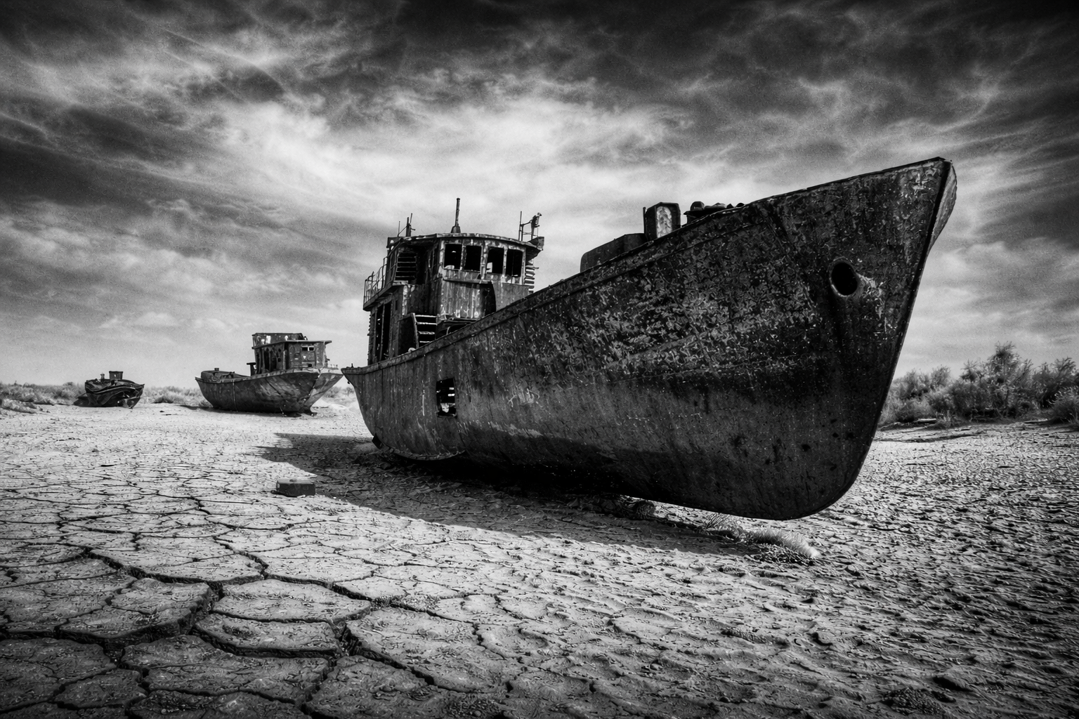
At the downstream end of this system lies the Aral Sea — a symbol of cumulative hydrological failure.
Once covering 68,000 square kilometers, the Aral has lost more than 90% of its volume since the
1960s. Over 50,000 square kilometers of exposed seabed now form the Aralkum Desert. Each year, an
estimated 75–100 million tons of salt and toxic dust are lifted into the atmosphere, spreading pesticide
residues across farmland and cities.
Even as Kazakhstan’s Kokaral Dam restored part of the North Aral Sea, the larger South Aral has largely
collapsed into hypersaline remnants.
Climate change is accelerating evaporation. Glacier retreat is reducing inflow. Recovery potential is
shrinking.
The Aral Sea is no longer only a historical disaster. It is a live warning of how warming and water
mismanagement combine to dismantle ecosystems within a generation.
- A Region Warming at Dangerous Speed
Central Asia is officially classified among the fastest-warming regions in the Northern Hemisphere.
Average temperatures have already risen 1.5–2°C since the mid-20th century. Under moderate
emissions, warming could reach 4°C by 2100. Under high-emission scenarios, projections suggest
6–6.5°C of regional warming.
That level of heat fundamentally reshapes hydrology.
Evaporation increases. Soil moisture declines. Drought periods lengthen. Heatwaves intensify. Climate
models suggest major cities could experience summer temperatures 3–4°C higher than current
norms, with heatwaves lasting weeks longer.
Agriculture — employing roughly 30–35% of the regional workforce and consuming 85–90% of
freshwater withdrawals — is already absorbing the shock.
The 2021 megadrought devastated pasturelands across western Kazakhstan and Turkmenistan, killing
tens of thousands of livestock. In 2024, extreme heat reduced Kazakhstan’s wheat yields by 20–25% in
affected regions, tightening supplies in one of the world’s major wheat-exporting countries.
Urban centers are also vulnerable. Rising cooling demand strains electricity grids. At the same time,
fluctuating river flows reduce hydropower reliability. Energy-water tensions intensify across shared basins.
Climate change in Central Asia is no longer about temperature alone. It is about systemic water
insecurity.
- The Aral Sea’s Last Gasp


No environmental collapse illustrates this crisis more clearly than the Aral Sea.
Soviet irrigation projects diverted 80–90% of river inflow to expand cotton monoculture. By the early
2000s, the lake had lost over 90% of its original volume.
Today, exposed seabeds release toxic dust that damages crops, corrodes machinery, contaminates soil,
and worsens respiratory disease across Kazakhstan and Uzbekistan. Rising regional temperatures —
now 1.5–2°C above historical baselines — accelerate evaporation, making ecological recovery
increasingly unlikely.
The Aral is a living indicator of what happens when heat, water diversion, and fragile governance
intersect.
- Compound Effect: Heat, Floods, Glacier, Dust
The crisis is no longer isolated to glaciers and rivers.
Since 2020, regional temperatures have remained about 1.5–2°C above mid-century averages, with
summer heatwaves frequently exceeding 40–45°C, and desert zones approaching 48°C. Human heat
stress is nearing physiological danger thresholds in some southern regions.
Meanwhile, high-mountain instability is increasing.
Central Asia contains over 4,500 glacial lakes, with approximately 1,000 classified as highly
dangerous. Glacial Lake Outburst Floods (GLOFs), landslides, and flash floods are increasing as
permafrost thaws and slopes destabilize. Sudden cloudbursts — intensified by a warmer atmosphere that
holds more moisture — overwhelm fragile mountain valleys.
Warmer winters reduce snowpack and shorten the natural storage cycle. Earlier melt contributes to spring
flooding and late-summer water shortages.
Desertification is expanding northward. Dust storms intensify. The Aralkum continues to generate salt-
laden plumes that travel across borders.
What is emerging is not a single hazard.
It is a cascading system: Extreme heat. Megadrought. Glacial retreat. River volatility. Flash floods. Dust
storms. Infrastructure stress.
Each amplifies the other
- A Region at a Threshold
Central Asia is no longer facing isolated climate anomalies. It is undergoing systemic environmental
transformation.
Mountains are thinning. Rivers are destabilizing. Deserts are expanding. Cities are overheating.
The water towers that made settlement possible are weakening.
And in a landlocked region bound together by shared rivers, instability upstream becomes vulnerability
downstream.
The climate crisis here is not just about temperature.
It is about survival systems — water, food, energy, health, and political stability — shifting all at once.
Climate Shock and Human Consequences

Across Central Asia, climate change is no longer an abstract environmental concern—it is already costing
lives, livelihoods, and public health on a large scale. Heatwaves, floods, droughts, and mountain hazards
are increasingly striking the region with greater intensity, creating a growing pattern of human and
economic loss. Between 2021 and 2025, these climate shocks caused thousands of fatalities and
disrupted the lives of millions. In 2023 alone, hydrometeorological disasters across Asia resulted in more
than 2,000 deaths, while the World Meteorological Organization (WMO) reported that nearly 9 million
people in Central Asia were affected by floods and storms that year. Rising temperatures are amplifying these disasters: the region has already warmed by around 1.5–2°C since the mid-20th century, almost twice the global average, intensifying heat stress, drought, and extreme weather.
Among these threats, extreme heat has emerged as one of the most dangerous drivers of human
risk. Summer temperatures across Kazakhstan, Uzbekistan, and Turkmenistan frequently exceed 40°C,
and some desert areas have recorded temperatures approaching 48°C. Studies by the World Bank and
regional climate researchers show that rising heat is already increasing heat-related mortality and
labor productivity losses, with tens of thousands of full-time job equivalents lost in 2023 alone due
to heat stress. Climate projections suggest that without rapid adaptation, Central Asia could face 3–4°C
additional warming in many cities by mid-century, meaning longer heatwaves, more heat-related
illness, and greater economic disruption.
The mountains, meanwhile, present a different but equally serious set of dangers. As glaciers retreat and
permafrost weakens, the risk of sudden disasters such as Glacial Lake Outburst Floods (GLOFs) is
rising. Scientific monitoring shows that Central Asia now contains more than 4,500 glacial lakes, with
around 1,000 classified as potentially dangerous. The Copernicus Emergency Management
Service (ESSD) database records 906 deaths linked to GLOFs across High Mountain Asia in recent
decades, though researchers believe the true figure is likely higher. National reporting highlights how
frequent these hazards have become: Kyrgyzstan alone experienced more than 370 mudflows in
2024, along with numerous floods and landslides that destroyed infrastructure, displaced communities,
and caused millions of dollars in economic damage.
These disasters often trigger wider public-health crises. Floods frequently damage drinking water
systems and sanitation networks, leading to spikes in diarrhoeal disease and vector-borne infections,
while prolonged heatwaves drive higher hospital admissions and mortality rates. Health assessments
supported by the WMO and WHO repeatedly warn that Central Asia faces a growing “compound health
burden,” where heat stress, contaminated water, and weakened infrastructure interact to magnify public-
health risks.
The economic consequences are equally severe and rising. Recurring droughts and increasingly
unpredictable river flows have already produced major crop failures and livestock losses, pushing rural
communities toward debt, migration, or abandonment of traditional livelihoods. According to World Bank
regional estimates, climate-related disasters and water-sector fragility now cost Central Asia around
$10 billion every year, and these losses are expected to increase as extreme weather intensifies.
Recent events illustrate this trend clearly. The 2021 megadrought, followed by several hot and dry
seasons, devastated pasturelands across Kazakhstan and Turkmenistan, killing tens of thousands of
livestock and reducing fodder supplies. Meanwhile, a 2024 extreme heat episode reduced wheat
yields in parts of Kazakhstan by around 20–25%, tightening grain supplies in one of the world’s major
wheat-exporting countries.
Another powerful health and environmental multiplier remains the Aral Sea disaster. The collapse of this
once-vast inland lake has exposed more than 50,000 square kilometers of seabed, forming the
Aralkum Desert. Each year, tens of millions of tons of salt- and pesticide-laden dust are lifted from
this dried basin and carried across Kazakhstan, Uzbekistan, and neighboring regions. These toxic dust
storms contaminate soils, damage crops, and worsen respiratory diseases, compounding the impacts of
heatwaves, floods, and water shortages.
For international organizations such as the WMO, World Bank, UNEP, and ICIMOD, the message is
increasingly clear: without urgent and coordinated action, the human cost of climate change in Central
Asia will continue to rise. Strengthening transboundary water management, expanding early-warning systems, investing in climate-resilient agriculture, and scaling up climate finance and social
protection are essential to reduce vulnerability.
Otherwise, the region risks entering a future where extreme heat, failing harvests, disease outbreaks,
and climate-driven migration become an increasingly common reality across Central Asia.
Closing the Gap: How Central Asia Can Respond

Central Asia’s climate crisis is intensifying, but it is not beyond management. Governments across the
region still have the ability to slow and adapt to these changes — provided the response is coordinated,
science-based, and supported by sustained financial investment. Because the region’s rivers, climate
systems, and economies are deeply interconnected, solutions cannot rely on isolated national policies.
Instead, effective adaptation requires strong regional cooperation and institutional coordination.
International organisations such as the World Bank, the World Meteorological Organization (WMO),
the UN Development Programme (UNDP), and the United Nations Environment Programme (UNEP)
consistently emphasise that climate resilience in Central Asia must begin with stronger governance and
cross-border collaboration. One of the most urgent priorities is the modernization of
hydrometeorological services and early-warning systems, which allow governments to anticipate
heatwaves, floods, and droughts before they escalate into disasters.
Programs such as the Hydromet Expert Services initiative, supported by the WMO and the World
Bank, are working to modernise weather monitoring and forecasting across Kazakhstan, Kyrgyzstan,
Tajikistan, Turkmenistan, and Uzbekistan. By sharing real-time climate data and improving regional
forecasting capacity, these systems can dramatically improve disaster preparedness. They are also
aligned with the global “Early Warning for All” initiative, which aims to ensure that every person on
Earth is protected by effective early-warning systems by 2027. Regional tools such as the Central Asian
Flood Early Warning System already demonstrate how pooled data and shared forecasting
infrastructure can help governments act before disasters occur rather than responding after the damage
is done.
However, forecasting alone cannot solve the region’s climate challenges. Central Asia must also reform
the way it manages water, energy, and agriculture, particularly in the shared basins of the Syr Darya
and Amu Darya rivers. The Central Asia Water and Energy Program (CAWEP), supported by the
World Bank, promotes integrated planning that links reservoir management, irrigation systems, and
hydropower generation across borders. Improving irrigation efficiency, reducing water losses from
outdated canal systems, and strengthening dialogue between upstream and downstream states could
significantly reduce tensions over water allocation while improving regional food and energy security.
Investment in modern irrigation technologies, renewable energy expansion, and sustainable
hydropower management is another critical step. Solar and wind power, in particular, offer strong
potential in Central Asia’s vast open landscapes, reducing pressure on hydropower systems that depend
on increasingly unpredictable river flows. According to World Bank estimates, deeper cooperation in
regional electricity trade and water–energy management could generate up to $6.4 billion in economic
benefits by 2030, highlighting how climate adaptation can also drive economic opportunity.
At the national level, governments are also beginning to integrate climate considerations into urban
planning and infrastructure development. Measures such as flood-resistant construction, improved
drainage systems, and green–blue urban infrastructure can help reduce flood damage, mitigate urban heat island effects, and protect critical services during extreme weather events. These policies are becoming increasingly important as climate projections suggest that many Central Asian cities could experience 3–4°C higher summer temperatures by mid-century, alongside longer and more intense heatwaves.
Encouragingly, regional political dialogue on climate cooperation is also growing. International forums
such as the Financing and Investment for Environmental Goals in Central Asia conference have
highlighted the need to mobilise larger flows of climate finance into the region. However, scaling these
efforts will require stronger domestic revenue systems, improved access to international funding
mechanisms such as the Green Climate Fund, and shared policy frameworks that treat climate
adaptation not as a secondary environmental issue but as a central pillar of economic and
development planning.
Ultimately, the path forward for Central Asia lies in cooperation. The region’s rivers, energy systems, and
climate risks do not respect national borders. Managing them successfully will require countries to share
data, coordinate infrastructure investments, and build institutions capable of responding to a rapidly
changing climate.
Without that cooperation, climate pressures will continue to intensify.
With it, Central Asia still has the opportunity to transform vulnerability into resilience.
Central Asia at a Climate Crossroads
Central Asia’s climate crisis runs far deeper than shrinking glaciers or declining river flows. The struggles
of the Syr Darya and Amu Darya are only one visible layer of a much broader environmental
transformation unfolding across mountains, deserts, cities, and steppes. Across the region, melting Tian
Shan and Pamir glaciers, thawing permafrost, expanding glacial lakes, intensifying heatwaves,
prolonged droughts, shifting snowfall patterns, and toxic dust storms from the Aral Sea basin are
converging into a cascading system of risk. Central Asia is warming faster than the global average, and
this acceleration is already reshaping water cycles, agricultural stability, public health systems,
infrastructure resilience, and even geopolitical relations between upstream and downstream states.
Rivers may be the arteries of Central Asia, but the climate crisis now runs through every sector of life —
from hydropower reservoirs and cotton fields to urban energy grids and mountain communities
increasingly exposed to landslides and flash floods.
At the same time, the climate emergency in Central Asia does not begin or end with the Syr Darya and
Amu Darya. These rivers represent only part of the region’s environmental stress, yet they remain its
most critical lifelines, sustaining tens of millions of people across multiple countries. Protecting them is
therefore essential. But genuine resilience will require far broader transformation: modernised irrigation
systems, climate-resilient infrastructure, stronger regional water-sharing agreements, expansion
of renewable energy, improved early-warning systems, desertification control, reforestation
programs, and sustained investment in public health and disaster preparedness.
International institutions such as the World Meteorological Organization, the World Bank, and the
United Nations repeatedly warn that without deeper regional cooperation and significantly increased
climate finance, the region’s risks will grow faster than its ability to manage them. In a region where water, energy, and agriculture are tightly interconnected across borders, isolated national responses will not be
enough.
Central Asia now stands at a decisive crossroads. The coming decades will determine whether the region
can stabilize its rivers, protect its people, and adapt to a rapidly warming climate — or whether escalating
heat, drought, floods, and dust storms will reshape its landscapes and societies in increasingly
irreversible ways.
The warning signs are already written across the region’s retreating glaciers, drying rivers, and rising
heat. What remains uncertain is not the scale of the challenge, but how quickly the world — and the
region itself — chooses to respond.
“The warning signs are no longer distant forecasts; they are written in dust, heat, and
– Climate Lens
retreating ice — and history will judge how the region chose to respond.”
Citation
University of Central Asia – Impact on Climate Change Report
World Meterological Organisation – State of Global Water Resources 2024
Down to Earth – Asia heating up twice
Science Direct – The State of future in Central Asia
MDPI – Changes in Tian Shan
World Meterological Organisation – Climate Change and extreme weather impact on Asia
Tajikistan National Commission on Irrigation and Drainage – Report
United Nation Enviornmental Programme – Change in Aral Sea
Optimize IAS – Daily Prelims
Copernicus Emergency Management Service (ESSD) – Glacial Lake Outburst Flood (GLOF) Database.
Asian Development Bank (ADB) – Climate Risk and Disaster Trends in Central Asia.
Leave a Reply